Hurricane Season runs from June 1-November 30


[10/10]


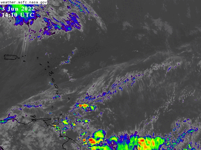
000
FXCA62 TJSJ 171953
AFDSJU

Area Forecast Discussion
National Weather Service San Juan PR
353 PM AST Wed Apr 17 2024

.SYNOPSIS...

Unstable weather conditions will continue to prevail across the
islands until the end of the workweek. Strong showers and
isolated thunderstorms are expected to continue over portions of
central and northern Puerto Rico through late this evening. Therefore,
there is the potential for minor flooding, river rises and
mudslides due to soil saturation.

&&

.SHORT TERM...Tonight through Friday...

Mostly sunny to partly cloudy skies were observed during the morning
hours across much of the region. The cloud coverage began to
increase across the Cordillera Central and eastern Puerto Rico by
the midday hours. By then, bands of heavy showers started to develop
from Maricao to Juana Diaz, and from Guayama to Luquillo. Doppler
radar estimated rainfall accumulations between 2 to 3 inches of
rain in the central area, whereas the southern slopes received
between 1 to 2 inches of rain. Several Flood Advisories (FLS) were
sent to these areas, due to minor flooding occurring at the
moment and the amount of rain received. In terms of temperatures,
the Luis Munoz Marin Int. Airport in San Juan had a maximum
temperature of 85 degrees Fahrenheit today. Overall, high
temperatures were seen in the upper 70s to low 80s across all the
islands. Winds were light to moderate with higher gusts with the
heaviest showers.

Moderate to heavy showers will continue moving along the Central
Cordillera through the afternoon hours. The San Juan metropolitan
area and adjacent municipalities may observed showers later in
the afternoon towards the evening hours. Rainfall accumulations
across these sectors could lead to ponding of water and minor
flooding in flood prone areas. By tonight into Thursday the shower
activity will slowly diminish across the region. A mid to upper
level trough will continue to shift eastward across the region
through Thursday. Then, it is expected to linger north of the
Leeward islands through the end of the workweek. Therefore, a mass
of unstable and moist air will continue to help the development
of rainfall activity throughout the area.

Across the U.S. Virgin Islands, the island St. Croix received the
most rainfall activity. Doppler radar observed up to 3 inches of
rain in the southwest corner of the island. The rainfall activity
will slowly diminish around sunset. For the rest of the islands,
mainly fair weather will continue to persist. However, passing
showers cannot be ruled out during the overnight hours. Overnight
temperatures will stay in the mid to upper 60s across the higher
elevations, and in the low to mid 70s across the coastal and urban
areas of the islands.

.LONG TERM...Saturday through Wednesday...

.PREV DISCUSSION.../Issued 441 AM AST Apr 17 2024/

Areas of low pressure spread across the central Atlantic basin and
developing surface high in the western Atlantic will maintain
moderate NE winds through the weekend along with enough water
content in a lingering airmass to allow passing showers and
afternoon convection to fire up due to diurnal heating and local
effects. By Sunday, an area of lower pressure near Florida will
assist the lifting of a moist airmass from the eastern Caribbean,
raising precipitable water values well above average values. This
in combination with a mid to upper-level trough, with the jet max
over the region through late Sunday, will allow an increase of
passing showers and afternoon convection mainly across western
Puerto Rico.

Winds begin to strengthen and veer, becoming more easterly to
southeasterly Monday to Tuesday, respectively, as the aforementioned
surface high moves into the central Atlantic. Due to all of this a
wet pattern is expected from Sunday onward with Wednesday containing
a best chance for widespread rainfall.

&&

.AVIATION...
(18z)

SHRA/TSRA are expected to continue across the local area through at
least 22z. Periods of reduced VIS and low CIGs are possible. Mtn obs
is also persist. Winds will turn light and variable aft 17/22z and
return form the NE at 10-15 kts aft 18/14z, with stronger gusts.

&&

.MARINE...

A surface ridge over the north-central Atlantic and broad surface
trough across the eastern Caribbean will generate moderate to locally
fresh east to northeasterly winds through tonight. An upper level
trough and induced surface trough will continue to promote inclement
weather across the local waters over the next few days, with squally
weather and thunderstorms possible at times. A northeasterly swell is
forecast to arrive by tomorrow.

&&

.SJU WATCHES/WARNINGS/ADVISORIES...
PR...None.
VI...None.
AM...None.
&&

$$

SHORT TERM...CVB
LONG TERM....GRS
PUBLIC DESK...MRR