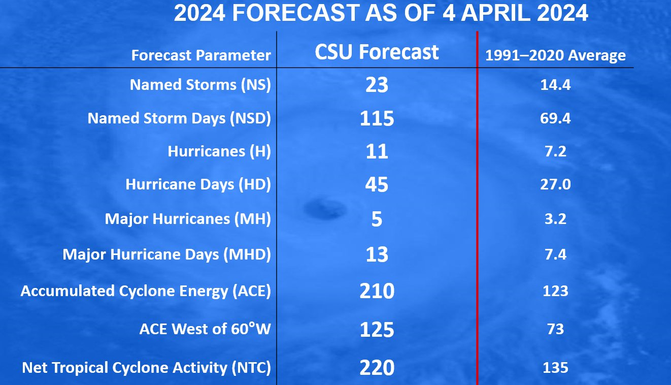
Hurricane Season runs from June 1-November 30


[10/10]


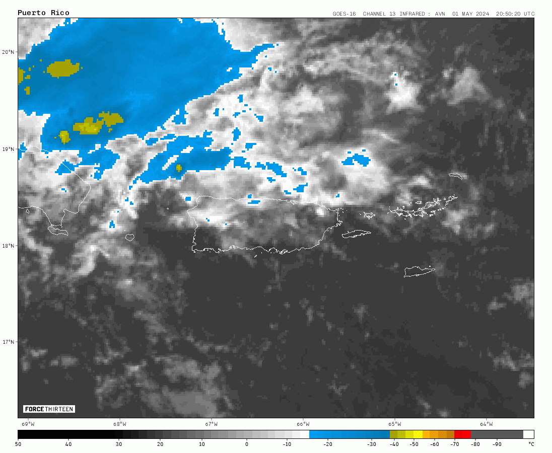
000
FXCA62 TJSJ 250912
AFDSJU

Area Forecast Discussion
National Weather Service San Juan PR
512 AM AST Thu Apr 25 2024

.SYNOPSIS...

Wet and unstable weather conditions are expected to prevail for
the next few days with limited to elevated risks of flash
flooding, urban and river flooding, and landslides mainly over the
interior, western, and northern Puerto Rico, as well as the San
Juan metro area. A slight improvement on weather condtions is
expected by Saturday night into Sunday as drier air filters into
the local area.

&&

.SHORT TERM...Today through Saturday...

Isolated to scattered showers affected the eastern third of Puerto
Rico and smaller islands during the night hours. However, most of
the activity remained over the Caribbean waters. Radar estimates
indicated up to 0.60 inches of rainfall fell mainly over and near El
Yunque. Similar activity is expected for the rest of the morning
hours over windward coastal areas.

According to the Tropical Analysis and Forecast Branch (TAFB)
surface analysis, the axis of the surface trough that has been over
the CWA for the past few days will finally move northwestward today.
However, plenty of columnar moisture, combined with diurnal heating
and local effects, along with marginal instability aloft, will
promote another active afternoon. Model guidance suggests that the
bulk of the activity will be clustered a bit further north than the
previous day steered by southeast to east-southeast winds.
Nonetheless, heavy showers and thunderstorm activity will generally
be observed in already saturated soils and areas with elevated
streamflows.

While the overall wet and unsettled weather pattern will persist for
the remainder of the short-term forecast, some changes have been
suggested by the latest model cycle for Friday and Saturday. Late
tonight through early Friday, we could observe a slight decrease in
showers, mostly across the eastern CWA, as a slot of slightly drier
air moves in. However, this respite won`t last long as the pre-
frontal trough currently affecting the Dominican Republic will
gradually move over the local area by Friday, increasing low-level
instability and moisture convergence over the region. Meanwhile, a
mid-level short-wave trough will strengthen and pass over the
northeastern Caribbean, further enhancing the potential for deep
convective activity. Therefore, another afternoon with widespread
activity is expected on Friday.

By Saturday, previous model cycles indicated a drying trend, which
was expected to limit the areal coverage of convective activity
across the area. However, the latest model cycle now suggests a
prolongation of above-normal moisture across the islands. The GFS
Galvez Davison Index suggests the potential for isolated to
scattered thunderstorms and heavy rainfall on Saturday afternoon,
delaying the transition to a more stable weather pattern.
Additionally, cold air advection at mid-levels will be high, with
500 mb temperatures falling between -8 and -9 degrees Celsius. This
will enhance low- to mid-level lapse rates and increase the
potential for strong thunderstorms capable of producing frequent
lightning and gusty wind conditions.

Overall, expect a wet and unstable weather pattern throughout the
short-term forecast, with limited to elevated risks of flooding and
lightning across the area, particularly over interior, western, and
northern Puerto Rico, as well as the San Juan metro area. Urban and
river flooding, flash flooding, and landslides will continue to
impact areas already affected in the past week. Please continue to
monitor the forecast in the next few days and pay attention to any
advisories or warnings that our office may issue.

.LONG TERM...Sunday through Thursday...

A strong surface high pressure moving off the eastern coast of the
united states, is expected to promote moderate to locally fresh
northeast winds at the beginning of the long-term period. The latest
model guidance have changed, delaying the departure of the
moisture from the local area. However, by Sunday remnant moisture
from a surface trough and old frontal boundary will be pushed
south of the region, improving gradually the local weather.
Variable weather conditions are expected from Sunday through
Tuesday, with passing showers over the east coast of Puerto Rico
and the U.S. Vrigin Islands. Then, followed by afternoon
convection across the southwest portions of PR due to the
combination of daytime heating and local effects. Precipitable
water values will remain between 1.40 to 1.50 inches through
Tuesday night. By Wednesday, a patch of very dry air will filter
into the region, limiting the potential of shower activity across
the islands. However, this fair weather pattern will not last
long due to the arrival of a big field of moisture pulled from
South America toward the eastern Caribbean region on early
Thursday. A wet and unsettled pattern is anticipated with an
elevated potential of showers and thunderstorms across the local
area. The general wind flow will be from the northeast then
veering from the east southeast by Thursday. Daytime temperatures
will remain in the mid 80s along the coastal and urban areas of
Puerto Rico and the U.S. Virgin Islands, and from the mid to upper
70s across the Cordillera Central.

&&

.AVIATION...
(06Z TAFs)

Expc mainly VFR conditions across all terminals through the forecast
period. However, areas of SHRA and SCT TSRA this aftn could produce
tempo MVFR/IFR conds and mtn obsc, particularly ovr TJBQ/TJSJ aft
25/17z. VCTS/SHRA at TJPS for the most part. ESE winds reaching
speeds of up to 8-12 knots, accompanied by higher gusts and sea
breeze variations aft 25/13z.

&&

.MARINE...

A small northwesterly swell is expected to spread across the local
waters today. Showers and thunderstorms will continue to affect the
local waters for the next few days. Another surface trough will
strengthen the easterly winds from today into Friday, before
becoming northeast on Saturday under the influence of a surface high
pressure moving off the eastern coast of the United States.

&&

.BEACH FORECAST...

Breaking waves of around 3 feet will maintain the risk of rip
currents generally moderate for the northern beaches of the local
islands.

&&

.SJU WATCHES/WARNINGS/ADVISORIES...
PR...None.
VI...None.
AM...None.
&&

$$

SHORT TERM...CVB
LONG TERM....GRS


