Hurricane Season runs from June 1-November 30


[10/10]


Area Forecast Discussion (AFD)
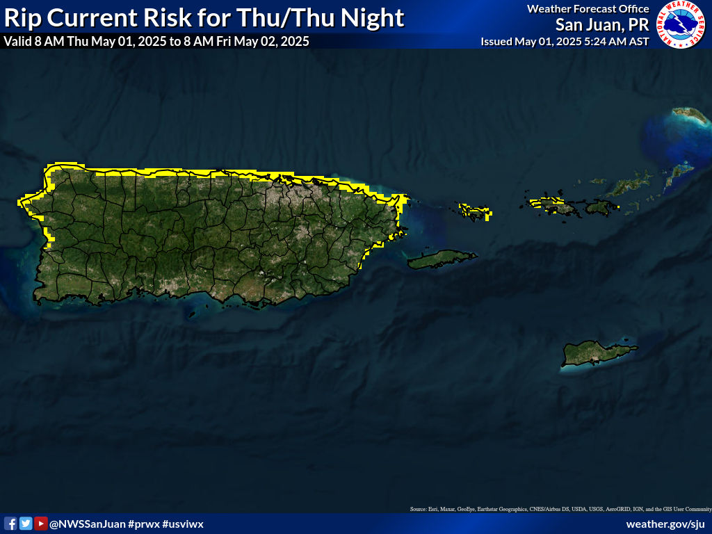
427
FXCA62 TJSJ 150700
AFDSJU

Area Forecast Discussion
National Weather Service San Juan PR
300 AM AST Mon Jun 15 2026

...New SHORT TERM, LONG TERM, AVIATION, MARINE, BEACH FORECAST, FIRE WEATHER...

.KEY MESSAGES...
Issued at 300 AM AST Mon Jun 15 2026

* Generally stable and fair weather will dominate, despite the
  possibility of a slight increase in moisture and shower activity
  toward the end of the week.

* Warm to hot conditions will continue, with elevated heat
  indices posing a risk to vulnerable populations and those
  spending prolonged time outdoors.

* Prolonged dryness, critically dry fuels, above-normal
  temperatures, and breezy conditions will continue to support an
  increased risk of rapid wildfire spread, especially across
  southern and western Puerto Rico.

* Breezy trade winds will maintain choppy marine conditions and a
  continued risk of rip currents along many exposed beaches.

&&

.Short Term(Today through Wednesday)...
Issued at 300 AM AST Mon Jun 15 2026

Broad surface high pressure over the North Atlantic will maintain
a prevailing east to east-southeast trade wind flow through the
period, steering intermittent patches of shallow moisture
interspersed with drier-than-normal air across the region. At the
same time, a persistent mid-level ridge and dry air aloft will
continue to suppress deep convection. As a result, expect mainly
brief, fast-moving passing showers across windward areas and
isolated to locally induced afternoon showers over western Puerto
Rico, with no significant rainfall accumulations anticipated.

A tropical wave moving through the Caribbean tonight into Tuesday
will remain well south of the local islands and have minimal
influence on the local weather pattern. Although the mid-level
ridge will gradually shift westward and an upper-level trough
retrogrades across the Atlantic by midweek, only subtle changes in
atmospheric conditions are expected. Precipitable water values
should remain generally below normal, briefly approaching seasonal
levels Tuesday night into early Wednesday, while persistent dry
air aloft continues to limit vertical cloud development. Overall,
limited shower activity is expected through Wednesday.

The primary hazards through the period will continue to be heat,
non-thunderstorm winds, and fire weather. Afternoon heat indices
will commonly exceed 100 degrees Fahrenheit, with isolated
locations reaching or exceeding 108 degrees. Wind speeds will
generally range between 15 and 20 mph, with gusts up to 30 mph,
especially across exposed coastal areas and the local islands.
Combined with dry fuels and limited rainfall, these conditions
will support an elevated fire danger risk across portions of
southern and western Puerto Rico. While the weather pattern may
appear favorable for outdoor activities, residents and visitors
should remain mindful of the heat, winds, and fire danger.

&&

.Long Term(Thursday through Monday)...
Issued at 300 AM AST Mon Jun 15 2026

Model guidance suggests a modest increase in moisture late this
week as a tropical wave passes south of Puerto Rico and the U.S.
Virgin Islands. At the same time, the persistent mid-level ridge
is forecast to shift west of the region while a lingering upper-
level trough east-northeast of the area exerts greater influence,
resulting in slight cooling aloft and a gradual weakening of the
trade wind cap. However, dry mid-level air is expected to persist,
and moderate Saharan dust concentrations forecast through Friday
should temper the overall coverage and intensity of showers and
thunderstorms.

As a result, only a modest increase in shower activity and the
potential for isolated thunderstorms is anticipated from Thursday
into Friday. While localized heavier downpours cannot be ruled
out, the prolonged dry pattern and significant rainfall deficits
should keep the overall flooding threat limited. Beyond Friday,
forecast uncertainty increases, but a generally typical trade-wind
pattern with passing showers and isolated afternoon convection is
expected to continue. Overall confidence in the long-term forecast
remains moderate, as the timing and interaction of these features
continue to vary among model guidance.

&&

.AVIATION...
(06Z TAFS)
Issued at 300 AM AST Mon Jun 15 2026

Mainly VFR conds will prevail at all TAF sites thru the fcst pd.
VCSH with brief -SHRA is psbl in the vcnty of TJSJ and TJBQ btwn
15/16Z-20Z due to iso aftn convection. Light concs of Saharan
dust will persist acrs the local area, resulting in locally hazy
skies with minimal VIS impacts. E-ESE sfc winds will incr to 15-20
kt with higher gusts and sea-breeze variations fm 15/14Z-23Z,
bcmg 10 kt or less ovrngt.

&&

.MARINE...
Issued at 300 AM AST Mon Jun 15 2026

A broad area of high pressure over the central Atlantic will
maintain moderate to fresh trade winds and choppy marine
conditions through much of the forecast period. Seas are expected
to range between 4 and 6 feet, with occasional higher waves across
the offshore waters and local passages, prompting Small Craft
Exercise Caution conditions. Winds may ease slightly by Tuesday
into Wednesday, allowing seas to gradually subside to 3 to 5 feet.
Overall, fair weather and limited shower activity are expected to
prevail, although a tropical wave approaching the northeastern
Caribbean later this week could bring a modest increase in
moisture and shower activity across the local waters.

&&

.BEACH FORECAST...
Issued at 300 AM AST Mon Jun 15 2026

Breezy to windy conditions will maintain a moderate risk of rip
currents for most beaches across Puerto Rico, including Culebra
and Vieques, as well as the U.S. Virgin Islands through at least
midweek. Life-threatening rip currents are possible, and
beachgoers should remain vigilant, swim near lifeguards when
available, and follow the guidance of local authorities and beach
warning flags.

A low risk of rip currents will continue along the western coast
of Puerto Rico. However, dangerous rip currents can still occur,
particularly near jetties, groins, reefs, and piers. Additional
rip current safety information is available at
weather.gov/beach/sju.

&&

.FIRE WEATHER...
Issued at 300 AM AST Mon Jun 15 2026

Persistent above-normal temperatures, breezy east to east-
southeast winds, and limited rainfall will continue as broad
surface high pressure maintains the trade wind flow and a
persistent mid-level ridge suppresses widespread precipitation.
Prolonged rainfall deficits, with some locations receiving less
than 5 percent of normal rainfall in recent weeks, combined with
abnormally dry to moderate drought conditions and KBDI values
exceeding 600 across much of southern Puerto Rico, will keep fuels
critically dry. Although a few passing showers are expected, no
meaningful wetting rainfall is anticipated. Therefore, a Fire
Danger Statement has been issued for today, and similar or even
locally critical fire weather conditions capable of supporting
rapid fire spread may continue over the next several days if the
current pattern persists.

&&

.SJU WATCHES/WARNINGS/ADVISORIES...
PR...None.
VI...None.
AM...None.
&&

$$

EVE...LIS/GRS
MID...ICP


![]()
Visits since November 23, 2005
Contact | Privacy Policy © 2025, WeatherPR.com – Your trusted source for Puerto Rico weather & travel tips.