Issued by: National Weather Service San Juan, PR
Updated: 2:11 pm AST May 25, 2026


| Memorial Day | Scattered showers. Partly sunny, with a high near 87. Breezy, with an east wind around 28 mph, with gusts as high as 34 mph. Chance of precipitation is 40%. |
| Tonight | Scattered showers. Mostly cloudy, with a low around 76. East wind 11 to 14 mph. Chance of precipitation is 50%. |
| Tuesday | Scattered showers. Partly sunny, with a high near 86. East wind 15 to 18 mph, with gusts as high as 23 mph. Chance of precipitation is 40%. |
| Tuesday Night | Scattered showers, mainly after midnight. Partly cloudy, with a low around 76. East wind around 10 mph. Chance of precipitation is 40%. |
| Wednesday | Showers likely, with thunderstorms also possible after noon. Mostly cloudy, with a high near 88. East wind 13 to 15 mph, with gusts as high as 20 mph. Chance of precipitation is 60%. |
| Wednesday Night | Isolated showers. Partly cloudy, with a low around 76. East wind 8 to 10 mph. Chance of precipitation is 20%. |
| Thursday | Sunny, with a high near 89. East wind 8 to 16 mph, with gusts as high as 21 mph. |
| Thursday Night | Scattered showers. Partly cloudy, with a low around 76. East southeast wind 7 to 10 mph. Chance of precipitation is 40%. |
| Friday | Showers likely, mainly after noon. Partly sunny, with a high near 90. East wind 8 to 18 mph, with gusts as high as 23 mph. Chance of precipitation is 70%. |
| Friday Night | Partly cloudy, with a low around 77. |
| Saturday | Showers likely. Partly sunny, with a high near 91. Chance of precipitation is 60%. |
| Saturday Night | Scattered showers. Partly cloudy, with a low around 78. Chance of precipitation is 30%. |
| Sunday | Scattered showers. Mostly sunny, with a high near 91. Chance of precipitation is 40%. |
959
FXCA62 TJSJ 251816
AFDSJU
Area Forecast Discussion
National Weather Service San Juan PR
216 PM AST Mon May 25 2026
...New SHORT TERM, AVIATION, MARINE, BEACH FORECAST, FIRE WEATHER...
.KEY MESSAGES...
Updated at 1250 PM AST Mon May 25 2026
* Breezy to windy conditions are expected the rest of today. A
Wind Advisory is in effect through this evening due east winds
around 25 mph and winds gusts up to 40 mph.
* Hazardous marine and coastal conditions will persist through at
least late Tuesday, with Small Craft Advisories and a high risk
of rip currents remaining in effect.
* Warm to hot conditions will persist through much of the week,
with hotter conditions anticipated by the end of the week.
* Afternoon showers and very isolated thunderstorms could still
impact western portions of Puerto Rico despite the arrival of a
drier airmass over the region today. Uptick of passing showers
across windward coastal areas and smaller islands tonight.
* Minor to moderate concentrations of Saharan dust are forecast to
arrive by midweek and persist into late week.
&&
.Short Term(This evening through Wednesday)...
Issued at 1250 PM AST Mon May 25 2026
Strong winds between 25 and 30 mph with gusts between 35 and 40
mph were observed across the islands today, particularly across
coastal areas. These windy conditions will continue through
tonight, and a Wind Advisory remains in effect through 8 PM AST.
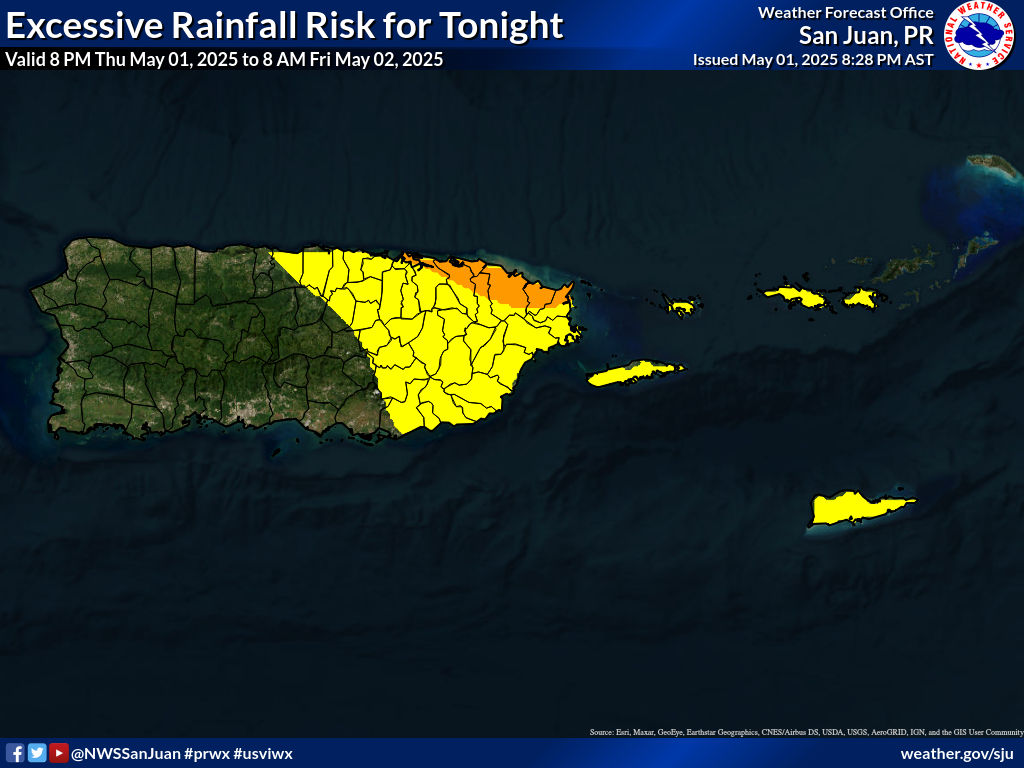
Quick passing showers will continue to move at times across the
islands, but rainfall accumulations should not cause flooding
concerns, except in western PR, where ponding of water is possible
this afternoon. The latest 12z TJSJ upper-air sounding shows a
relatively low precipitable water (PWAT) of 1.29 inches, with a
persistent mid-level dry slot and a capped environment. However,
satellite imagery from the MIMIC-Total Precipitable Water product
captures plenty of tropical moisture just to our south and east.
GFS guidance shows PWAT values rapidly surging above the 75th
percentile, peaking near 2.10 inches by Tuesday afternoon. This
surge in moisture will be accompanied by 925 mb wind speeds of 20
to 25 knots and the erosion of the mid-level inversion, as
700-500 mb lapse rates steepen to near 6.5-7.0 C/km and 500 mb
temperatures linger near normal values around -8 C.
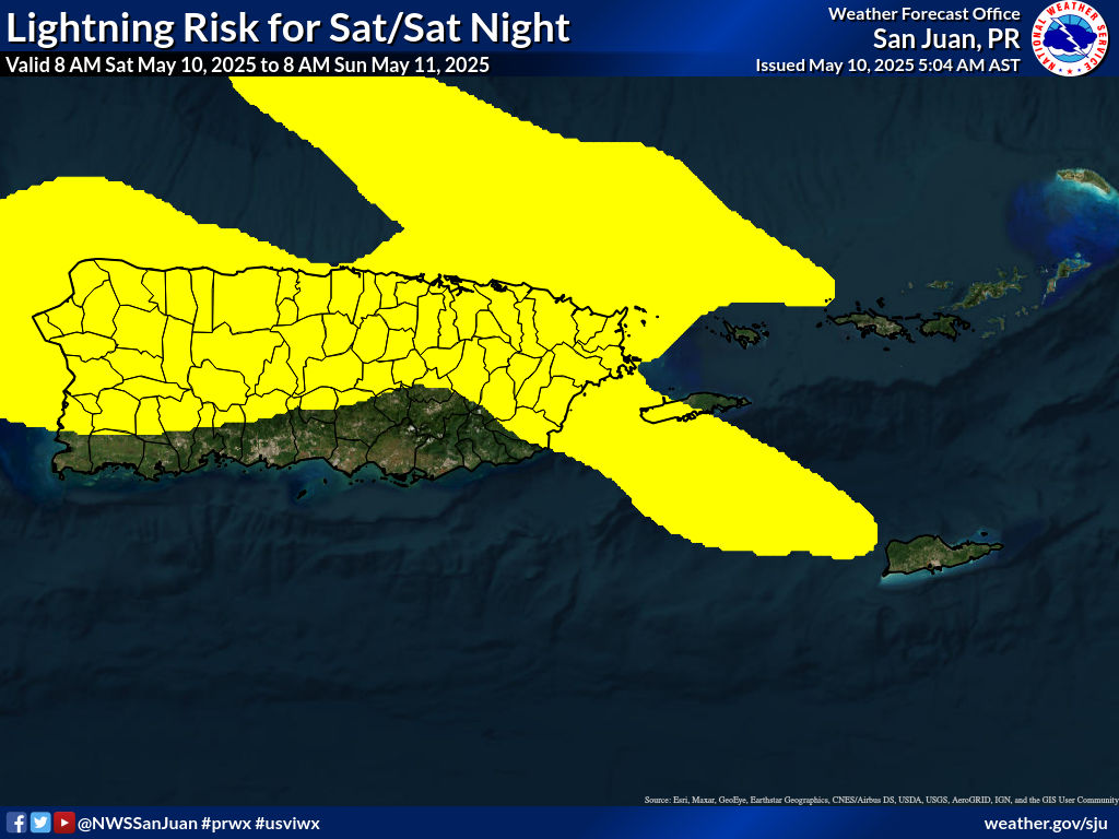
As this moisture combines with daytime heating and local effects,
widespread showers and isolated thunderstorms will develop. From
late tonight into Tuesday morning, showers will gradually increase
from the Caribbean waters into the USVI and the southeastern
sections of PR as the surge in moisture reaches the islands. In
terms of hi-res guidance, the ECMWF ensemble has a more aggressive
solution, with a larger convective footprint across the region and
rainfall accumulations of 2 to 4 inches, mainly across SE and NW
PR. At the same time, the NBM focuses shower activity on the same
areas, but with lower amounts. Given the high PWAT environment and
the potential for training cells, urban and small-stream flooding,
along with localized mudslides in steep terrain, will become the
main hazards. Shower activity will slowly taper off or become more
localized by Wednesday as the bulk of the moisture plume shifts
further west. However, lingering moisture and diurnal heating will
still trigger afternoon convective development across the interior
and western sections of Puerto Rico.
&&
Long Term(Thursday through Monday)...
Issued at 301 AM AST Mon May 25 2026
The long-term forecast remains on track. At the surface, lingering
moisture associated with a previous tropical wave will remain across
the forecast area, with PWAT values around 2.10 inches. This pattern
will promote a wetter and "muggy" weather pattern, supporting shower
development across the islands with periods of moderate to heavy
rainfall. A broad high pressure extending into the central Atlantic
will maintain east-southeasterly winds, promoting warm conditions
across northern and western Puerto Rico. Additionally, the NASA
Goddard Earth Observing System model continues to indicate a
significant pulse of Saharan Air Layer moving into the region
through the day. This increase in suspended dust particles will
result in hazy skies and warmer daytime temperatures. Stable
conditions at the mid-levels due to a strengthening ridge aloft may
gradually limit widespread thunderstorm activity, although local
effects and available moisture will still support afternoon
convection across the interior and northwestern Puerto Rico. Urban
and small-stream flooding, ponding of water on roads, isolated
lightning strikes, and gusty winds will remain possible with the
strongest showers. Heat indices may also reach elevated levels
across urban and coastal areas due to the combination of warm
temperatures and high humidity.
From Friday through Sunday, the available moisture is forecast to
migrate northward as a drier air mass filters into the northeastern
Caribbean, lowering PWAT values generally between 1.60 and 1.80
inches. Surface winds will persist from the southeast as the
Atlantic high pressure remains the dominant weather feature across
the region. This pattern, combined with higher 925 mb temperatures
and increasing Saharan dust concentrations, will promote a notable
warming trend through the weekend. Under periods of limited cloud
coverage, heat indices may rise between 108 and 111 degrees across
northern, western, and urban coastal sections of Puerto Rico. Hazy
skies and poor air quality may also affect sensitive groups,
including individuals with respiratory conditions and allergies.
Although a drier and more stable pattern is expected overall, local
effects and daytime heating will continue to trigger afternoon
convection each day, mainly across the northwestern quadrant of
Puerto Rico. On Sunday, a slight surge of moisture may increase
shower development once again, resulting in more active afternoon
convection across portions of western Puerto Rico. On Monday, both
the global GFS and ECMWF models suggest a significant drying trend,
with precipitable water values dropping to around 1.2 inches. This
drastic change will result from a large pulse of drier air
associated with a Saharan Air Layer intrusion, enough to promote
widespread hazy skies and a continued warm trend across the
region.
&&
.AVIATION...
(18Z TAFS)
Issued at 1250 PM AST Mon May 25 2026
Mainly VFR conditions are expected to prevail across all
terminals. However, -SHRA from streamers may lead to brief MVFR
conds at TJSJ this afternoon. There is a low chance for -TSRA to
develop mainly in the vcty of TJBQ thru 25/22z. Strong E winds
will continue at 18-22 kt with gusts near 30 kt through tonight.
&&
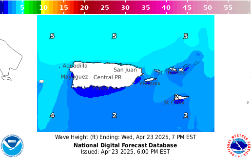
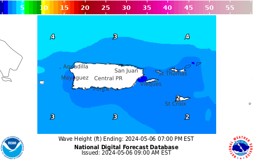
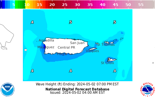
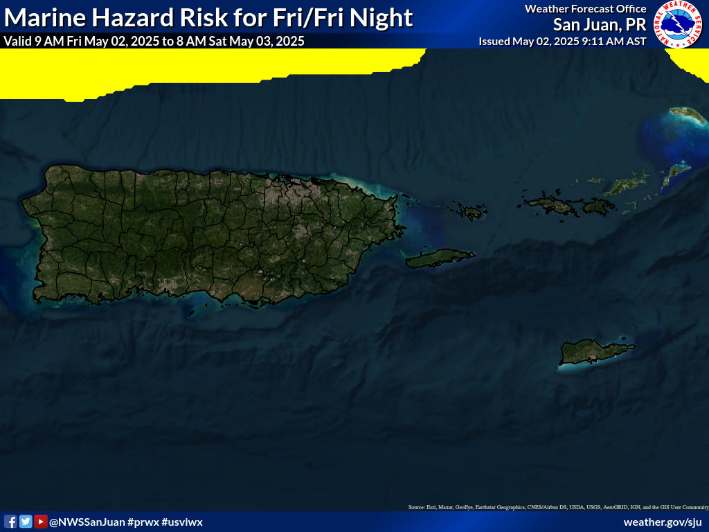
.MARINE...
Issued at 1250 PM AST Mon May 25 2026
A strong high pressure over the central Atlantic continues to
maintain a tight pressure gradient across the northeastern
Caribbean. Small Craft Advisories remain in effect for the
offshore waters through Tuesday night and for the local passages
through at least Tuesday afternoon, as moderate to locally strong
easterly winds continue to generate choppy to rough seas of up to
7 feet. During the second half of the week, conditions will
gradually improve as winds subside to a gentle to moderate range.
Mariners should also be aware of afternoon thunderstorms
developing near the western coastal waters of Puerto Rico each
day, which may produce locally higher winds and seas.
&&
.BEACH FORECAST...
Issued at 1250 PM AST Mon May 25 2026
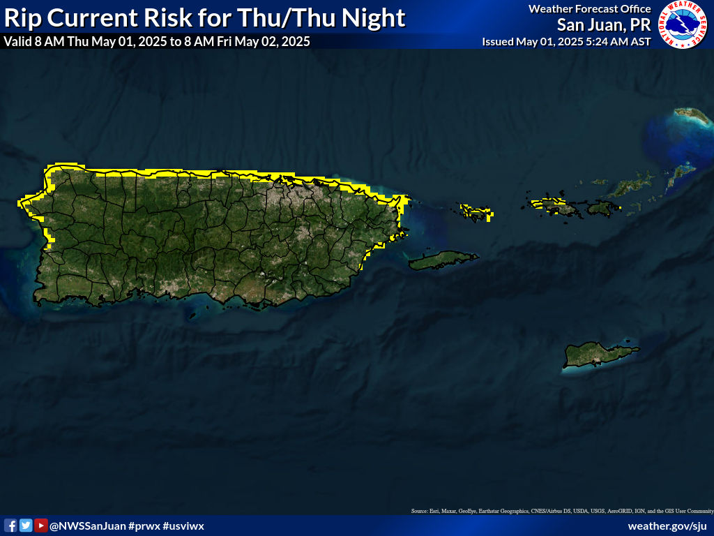
Breezy to windy conditions are maintaining a high risk of life-
threatening rip currents across the northern, eastern, and
southeastern beaches of Puerto Rico, as well as Vieques, Culebra,
and the U.S. Virgin Islands through at least tomorrow, Tuesday.
This means that life-threatening rip currents are likely in the
surf zone. Therefore, a Rip Current Statement remains in effect.
Beachgoers are urged to exercise caution and follow the advice of
local officials and beach safety personnel.
Beginning midweek, the risk will slightly decrease as winds
subside, but a moderate risk of rip currents will persist along
northern and eastern exposed beaches. By next weekend, forecast
guidance suggests increasing winds, which could cause the moderate
risk to expand to most beaches.
Another beach hazard will be rapidly changing weather conditions
and afternoon thunderstorms each day across western Puerto Rico.
If thunder is heard, seek shelter immediately inside a building.
&&
.FIRE WEATHER...
Issued at 1250 PM AST Mon May 25 2026
As anticipated, little to no rainfall has occurred across the
southern sections of Puerto Rico today, and drier air is moving
into the region, as indicated by satellite-derived PWAT imagery
showing values of 1.5 inches or less. Relative humidity values
have been in the upper 40s to low 50s along the southern coastal
plains, with wind speeds of 16 to 25 mph and gusts up to 33 mph in
the same areas. Therefore, conditions remain favorable for the
spread of wildfires across the southern coastal plains of Puerto
Rico, and the Fire Danger Statement (RFDSJU) remains in effect
through this afternoon.
&&
.SJU WATCHES/WARNINGS/ADVISORIES...
PR...High Rip Current Risk through Tuesday afternoon for PRZ001>003-
005-008-012-013.
Wind Advisory until 8 PM AST this evening for PRZ001>013.
VI...High Rip Current Risk through Tuesday afternoon for VIZ001-002.
Wind Advisory until 8 PM AST this evening for VIZ001-002.
AM...Small Craft Advisory until midnight AST Tuesday night for AMZ711-
712.
Small Craft Advisory until noon AST Tuesday for AMZ716-723-726-
733-741.
&&
$$
SHORT TERM/AVIATION...DSR
LONG TERM...LIS
MARINE/BEACH/FIRE...YZR