Hurricane Season runs from June 1-November 30


[10/10]


Area Forecast Discussion (AFD)
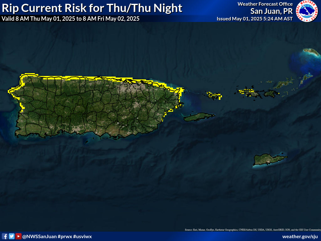
481
FXCA62 TJSJ 121813
AFDSJU

Area Forecast Discussion
National Weather Service San Juan PR
213 PM AST Fri Jun 12 2026

...New SHORT TERM, AVIATION, MARINE, BEACH FORECAST, FIRE WEATHER...

.KEY MESSAGES...
Issued at 213 PM AST Fri Jun 12 2026

* Mostly fair weather conditions are expected this weekend.
  However, showers and thunderstorms are expected this afternoon
  across the interior and western portions of Puerto Rico, but
  activity will be more localized than the previous days.

* Hot heat index values will prevail throughout the weekend,
  especially across urban, coastal, and lower-elevation areas.

* Saharan dust particles will continue to produce hazy skies,
  particularly through the weekend, though effects should lessen
  after tonight as concentrations diminish.

* A low fire weather risk is expected today across southern
  Puerto Rico and Saint Croix. Breezy and dry conditions may
  increase fire danger on Saturday.

* A moderate risk of life-threatening rip currents will persist
  along the north- and east-facing beaches of Puerto Rico and the
  U.S. Virgin Islands, expanding to southern Puerto Rico from
  Sunday into early next week as winds strengthen.

&&

.Short Term(This evening through Sunday)...
Issued at 213 PM AST Fri Jun 12 2026

Partly cloudy to cloudy skies prevailed across the local area
today. The most unstable portion of the upper-level trough
remained well north of the region, however, a few thunderstorms
developed over the surrounding waters. One of these storms moved
across portions of the south-central municipalities during the
morning hours, producing approximately 0.25 to locally 0.50 inches
of rainfall based on radar estimates. Daytime temperatures ranged
from the upper 80s to lower 90s across coastal areas of Puerto
Rico and the U.S. Virgin Islands, while mountain locations
remained in the lower 80s. Heat indices generally ranged from the
upper 90s to lower 100s, with localized values reaching between
105 and 109 degrees. Winds were mainly from the east at 10 to 15
mph, with higher gusts and sea-breeze variations.

This afternoon, some isolated to scattered showers and thunderstorms
are expected across the interior and western portions of Puerto
Rico, but activity will be more localized than the previous
days. From tonight onward, a drier air mass will gradually
dominate the local weather pattern. A strengthening surface high-
pressure system over the Atlantic will promote breezy to windy
conditions through the weekend, particularly on Sunday. Aloft, the
trough is expected to weaken while 500 mb temperatures gradually
warm. The latest model guidance indicates precipitable water
(PWAT) values decreasing to below-normal levels for this time of
year, supporting a transition toward more stable atmospheric
conditions.

Under this pattern, brief passing showers will remain possible
across windward areas during the overnight and morning hours,
followed by isolated afternoon showers across portions of
northwestern and western Puerto Rico. Overall shower activity
should remain limited, with little to no flood risk anticipated.
Warm to hot temperatures will persist through the weekend, and an
elevated heat risk is likely to continue across urban and coastal
areas of Puerto Rico and the U.S. Virgin Islands.

&&

.Long Term(Monday through Friday)...
Issued at 148 AM AST Fri Jun 12 2026

Some changes were introduced to the long-term forecast. As discussed
in previous discussions, a surface high pressure building and
lingering through most of the period, promoting E-ESE winds that
will lead to breezy to locally windy conditions across the islands.
Through Wednesday, drier air masses, along with minor
concentrations of SAL, and patches of moisture embedded in the
trades will likely move across the region, with PWAT values
fluctuating mainly between 1.3 and 1.6 inches. Taking a look at
the latest cross-section, the highest moisture content
concentrates in the 1000 - 850 mb layer, while RH values drop to
10 - 30 % in the 700 - 500 mb layer. A mid- level ridge should
linger through Wednesday, maintaining typical and slightly warmer
than normal 500 mb temperatures (between -6 and -7 degrees
Celsius), allowing subsidence and stability aloft. From Monday
through early Thursday, isolated showers may move from time to
time over windward sections, with shallow afternoon convection
over portions of western/northwestern Puerto Rico. Since rainfall
accumulations should remain limited, no flooding threat is
expected. By late Thursday, the latest global solutions suggest an
increase in moisture content, associated with a tropical wave
that may move south of the CWA and a TUTT that could amplify and
move closer to the region. While PWAT values should increase
between 1.5 and 1.75 inches, the TUTT may cool mid-level
temperatures, suppress high- level heights, and enhance vertical
motion. These conditions should increase instability across the
CWA, enhancing the potential of deep convection and lightning
threat. Therefore, isolated to scattered showers and isolated
thunderstorms may move over the windward sections by Thursday
evening. Nevertheless, the highest flooding potential can be
expected late Thursday night into Friday.

Typical to warmer than normal conditions can be expected through the
long-term, which may increase the chance of heat indices exceeding
100 degrees Fahrenheit. Hence, the heat threat will remain limited
to elevated across urban and lower elevations of the islands. Heat
Advisories will be issued if required.

&&

.AVIATION...
(18Z TAFS)
Issued at 213 PM AST Fri Jun 12 2026

Mainly VFR conditions are present across all TAF sites. VCTS and
TSRA possible across TJBQ around from 12/18Z-20Z. Low to moderate
concentrations of HZ will remain present over the forecast period
and could result in slight VIS reductions. ESE winds around 10-15
kts with higher gusts and sea breeze variations thru 12/22-23Z,
becoming 10 kts or less overnight. Main aviation concern tomorrow
will be increasing winds aft 13/13Z, expect breezy to windy conds.


&&

.MARINE...
Issued at 213 PM AST Fri Jun 12 2026

Moderate east to east-southeast winds and seas of 2 to 4 feet
will prevail across the regional waters through tonight. However,
a strengthening surface high pressure system over the Atlantic
will promote fresh trade winds and choppy marine conditions from
Saturday through at least the middle of next week. Seas are
expected to build to 4 to 6 feet, occasionally higher, across the
regional waters and local passages. Small craft operators will be
advised to exercise caution across the regional waters and local
passages as seas build and trade winds strengthen. Drier air and
slightly hazy skies associated with Saharan dust will persist
through the weekend.

&&

.BEACH FORECAST...
Issued at 213 PM AST Fri Jun 12 2026

Tonight, a moderate risk of rip currents will return to the
northern beaches of Puerto Rico and Culebra.

By Saturday, winds will gradually increase, becoming breezy to
locally windy. As a result, a moderate risk of rip currents will
expand to most beaches of Puerto Rico, as well as Culebra,
Vieques, and the U.S. Virgin Islands. A moderate risk means that
life-threatening rip currents are possible in the surf zone.
Beachgoers should exercise caution, always swim near a lifeguard
and remember to heed the advice of the local beach patrol and flag
warning systems. These conditions are expected to persist through
the weekend and into at least early next week.

A low risk of rip currents will remain along the western beaches
of Puerto Rico. However, life- threatening rip currents can occur
even when the risk is low, especially near groins, jetties, reefs,
and piers. Remain cautious. For additional information and
location-specific rip current forecasts, visit weather.gov/beach/sju.

&&

.FIRE WEATHER...
Issued at 213 PM AST Fri Jun 12 2026

The rest of today, a low fire weather risk is expected across the
southern sections of the islands. By tonight into Saturday
(tomorrow), a dry air mass will move into the area, potentially
lowering relative humidity values to near or below critical
thresholds across the southern coastal plains and possibly
adjacent areas.

Breezy conditions will gradually return over the weekend.
Combined with above-critical KBDI values and increasingly dry
fuels, these conditions may result in elevated fire danger.
Conditions could become favorable for wildfire spread across the
southern coastal plains of Puerto Rico on Saturday. A Fire Danger
Statement (RFDSJU) may be needed if current trends continue.


&&

.SJU WATCHES/WARNINGS/ADVISORIES...
PR...None.
VI...None.
AM...None.
&&

$$

SHORT TERM/MARINE/BEACH/FIRE...YZR
LONG TERM...MNG
KEY MESSAGES/AVIATION...CVB


![]()
Visits since November 23, 2005
Contact | Privacy Policy © 2025, WeatherPR.com – Your trusted source for Puerto Rico weather & travel tips.