


Atlantic Hurricane Season 2020 Storm Names
| Arthur | Bertha | Cristobal | Dolly | Edouard | Fay | Gonzalo | Hanna | Isaias | Josephine | Kyle | Laura | Marco | Nana | Omar | Paulette | Rene | Sally | Teddy | Vicky | Wilfred |
Hurricane Season runs from June 1-November 30
Click on the county or coastal water zone of interest to get the latest forecast from the National Weather Service.
Caribbean Sea Satellite

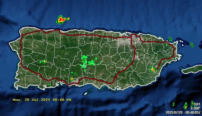
NWS San Juan Doppler Radar

Day 1 rainfall

Day 2 rainfall

Day 3 rainfall

Weather Summary for Puerto Rico
800 FXCA62 TJSJ 100601 AFDSJU Area Forecast Discussion National Weather Service San Juan PR 201 AM AST Wed Jun 10 2026 ...New SHORT TERM, LONG TERM, AVIATION, MARINE, BEACH FORECAST, FIRE WEATHER... .KEY MESSAGES... Issued at 132 AM AST Wed Jun 10 2026 * Cloudiness associated to an approaching trough and a weak tropical wave will limit the widespread potential for experiencing extended period of heat. Therefore, a heat Advisory was not issued for today. * A wetter and more unstable weather pattern is expected on late today and especially Thursday as a tropical wave interacts with an approaching upper-level trough, increasing the coverage of showers and thunderstorms across the region, and posing the greatest risk of flooding for Thursday. * Traces of Saharan dust will persist through the forecast period, producing somewhat hazy skies and reduced air quality, especially trailing the wave into early Saturday. * The potential for life-threatening rip currents will turn moderate from Thursday onward, first across St Croix, then spreading to the rest of the east and north-facing beaches in the USVI and PR. && .Short Term(Today through Friday)... Issued at 132 AM AST Wed Jun 10 2026 Overnight, calm weather conditions prevailed across Puerto Rico and the U.S. Virgin Islands. Mostly clear skies over urban and coastal areas allowed temperatures to drop into the 70s, while partly cloudy skies across the interior and higher elevations kept temperatures in the 60s. Winds remained light and variable through the night. Today will remain warm, although increasing cloudiness from an approaching trough and weak tropical wave should limit the extent of widespread heat indices above 100F. Still, isolated north-central and western areas of Puerto Rico could briefly reach Heat Advisory criteria this afternoon. Residents and visitors, especially heat-sensitive individuals, should continue following heat safety recommendations. Lingering Saharan dust may also affect air quality, and people with respiratory conditions are encouraged to follow health guidance. That being said, moisture will gradually increase as the trough and tropical wave approach the region. This will raise the potential for showers and thunderstorms this afternoon, mainly across the interior to western Puerto Rico, with additional activity possible downwind of the U.S. Virgin Islands, El Yunque, and the San Juan metropolitan area. Periods of heavy rain could lead to ponding of water on roads, localized urban flooding, and minor flooding in poorly drained areas. Thursday is expected to be the wettest and most unstable day of the short-term forecast period. Model guidance continues to indicate precipitable water and mid-level relative humidity values rising into the 75th percentile or above climatological normals for this time of year, particularly from late Wednesday into Thursday. In addition, 500 mb temperatures near -8 degrees Celsius will support enhanced instability aloft. This combination of abundant moisture and favorable atmospheric conditions is expected to promote more widespread shower and thunderstorm development. As a result, the risk of urban and small stream flooding will remain elevated, particularly in vulnerable and poorly drained areas. Conditions are expected to improve gradually by Friday as moisture decreases and atmospheric conditions gradually stabilizes, leading to quieter and more typical weather conditions heading into the weekend. && .Long Term(Saturday through Wednesday)... Issued at 132 AM AST Wed Jun 10 2026 In general, drier air with embedded patches of moisture will filter into the region steered by up to breezy E to ESE flow (backing to become more easterly late in the period). This will steer showers over windward sectors and, with diurnal heating and local effects, help develop shallow afternoon convection over western/northwestern Puerto Rico. Additionally, lines of showers can also develop downwind of the local islands and El Yunque. Ponding of water over roadways and poorly drained areas continues to be possible. Discrepancies continue between the GFS and ECMWF model guidance to start the workweek, with the GFS suggesting an upper-level trough lingering near the region and above normal PWAT values and the ECMWF suggesting more mid-level ridging and generally drier air. The GFS seems to lean more towards a ridging pattern than yesterday; a more seasonal pattern was added to start the next week. 925 mb temperatures are forecast to continue at or above normal, prompting a limited to possible elevated heat risk each late morning to late afternoon. Heat indices can reach and exceed 100 degrees Fahrenheit at urban and lower elevations areas of the islands. Saharan Dust will continue to filter over the local islands during the long term period. Current model guidance also suggests higher concentrations approaching the islands after the long term period. && .AVIATION... (06Z TAFS) Issued at 132 AM AST Wed Jun 10 2026 VFR conditions across all TAF sites. Expect the SE winds around 8-15 kt with higher gusts and sea breeze after 10/13Z. VCSH and VCTS possible across western Puerto Rico, affecting TJBQ between 10/18Z and 10/23Z. && .MARINE... Issued at 132 AM AST Wed Jun 10 2026 The Azores high pressure and a surface high building in the western Atlantic will promote light to moderate east to east-southeast winds across regional waters, becoming moderate to locally fresh by Friday. Strengthening winds will result in choppy seas, particularly across offshore waters, that may create locally hazardous conditions for small craft. A tropical wave approaching the Caribbean Basin will likely increase shower and thunderstorm activity on Thursday, particularly during the afternoon and evening. Mariners should exercise caution as stronger winds and higher seas can be expected near thunderstorms. && .BEACH FORECAST... Issued at 132 AM AST Wed Jun 10 2026 No changes were introduced to the beach forecast. The low risk of rip currents should continue today as winds remain weak, resulting in breaking waves between 1 and 3 feet across most beaches of the islands. Although the risk is low, beachgoers should be aware of isolated, stronger rip currents that may occur, particularly near groins, jetties, reefs, and piers. As the local pressure gradient gradually increases, winds should strengthen Thursday onward, increasing the risk of rip currents to moderate. The risk should begin over the northern and eastern beaches of Puerto Rico, spreading across most beaches of the islands by the weekend into early next week. Under a moderate risk, life-threatening rip currents are possible along the surf zone, beachgoers must exercise caution. Besides rip currents, beachgoers should keep in mind the possibility of showers and isolated thunderstorms moving over coastal areas each afternoon through Friday, with a higher chance over western and northern Puerto Rico. Beachgoers can expect gusty winds and lightning near thunderstorms, and they must seek shelter whenever they hear thunder. && .FIRE WEATHER... Issued at 132 AM AST Wed Jun 10 2026 RH values will range around 40 to 50 percent but will increase gradually by late today through Thursday. Winds will remain relatively low or below 15 mph meaning that there are limiting factors for maintaining an elevated fire threat for today. Therefore, expect a LOW fire weather risk across the southern sections of the islands, as brief conditions will be present. && .SJU WATCHES/WARNINGS/ADVISORIES... PR...None. VI...None. AM...None. && $$ SHORT TERM/AVIATION/FIRE WEATHER...MMC LONG TERM...MRR MARINE/BEACH FORECAST...MNG |
Tropical Atlantic Satellite

Latest Earthquakes near Puerto Rico
Saharan Air Layer

Wind Shear Tendency

Sea Surface Temperatures

Sea Surface Temperatures Anomalies
