


Atlantic Hurricane Season 2020 Storm Names
| Arthur | Bertha | Cristobal | Dolly | Edouard | Fay | Gonzalo | Hanna | Isaias | Josephine | Kyle | Laura | Marco | Nana | Omar | Paulette | Rene | Sally | Teddy | Vicky | Wilfred |
Hurricane Season runs from June 1-November 30
Click on the county or coastal water zone of interest to get the latest forecast from the National Weather Service.
Caribbean Sea Satellite

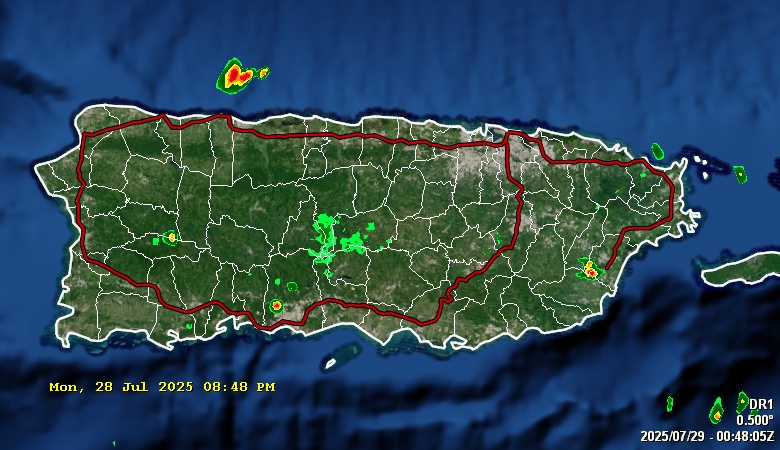
NWS San Juan Doppler Radar

Day 1 rainfall

Day 2 rainfall

Day 3 rainfall

Weather Summary for Puerto Rico
997
FXCA62 TJSJ 062021
AFDSJU

Area Forecast Discussion
National Weather Service San Juan PR
421 PM AST Thu Feb 6 2025

.SYNOPSIS...

Over the next few days, intermittent passing showers are expected
across the U.S. Virgin Islands and eastern to northern sections
of Puerto Rico overnight and early in the mornings. Additionally,
localized afternoon convection is possible over the interior to
west-southwestern sections of Puerto Rico. Breezy to windy
conditions will persist from the ENE. Small craft operators should
avoid hazardous seas caused by winds, which will continue through
the weekend.

&&

.SHORT TERM...Tonight through Saturday...

Mostly sunny to partly cloudy skies prevailed across all the islands
today. Scattered showers were noted earlier in the morning across
eastern and northern PR, as well across the USVI. However, as drier
air filtered over the area, showers decrease in coverage and
intensity during the afternoon hours. Breezy conditions were noted
with gusts between 30 and 33 mph observed in St. Croix, San Juan,
Aguadilla, and Ponce. Maximum temperatures were from the mid 80s to
90 degrees across the lower elevations, to the upper 70s and mid 80s
across the higher elevations.

A surface high pressure over the western Atlantic will continue to
move eastward into the north-central Atlantic by Saturday. This will
continue to result in breezy conditions across the northeastern
Caribbean with low-level 20-25 kt trades through at least Friday. A
similar weather pattern is expected to prevail each day with showers
moving mainly over land areas across the USVI and the east/northern
sections of PR during the night and early morning hours. An upper
level ridge will promote overall stable conditions aloft and a weak
SAL will continue to provide drier air in general at the low to mid-
levels. However, weak trade wind perturbations will reach the
islands from time to time to enhance the advective weather pattern
during the night/early morning periods. A weak upper level trough
will briefly promote colder 500 mb temperatures on Saturday, and in
combination with the arrival of a trade wind perturbation, showers
are expected to increase in coverage and intensity from late Friday
through Saturday. Seasonal temperatures will continue under the
prevailing east to northeasterly trades.

&&

.LONG TERM...Sunday through Thursday...
.PREV DISCUSSION... /issued 509 AM AST Thu Feb 6 2025/

A surface high pressure system will be centered northeast of the
Caribbean during the weekend, but it will extend north of the area
early next workweek. This will maintain a tight pressure gradient,
with breezy east to east-northeasterly winds early next week, and
breezy to locally windy conditions but with a more easterly
component during most of the next workweek. These winds will keep an
advective pattern with patches of moisture reaching our area from
time to time, increasing the frequency of passing showers across the
windward sections of the islands. A weak mid to upper level trough
will cross the area on Sunday, maintaining some instability aloft.
Depending on the timing of the patches of moisture, this could help
boost the local rainfall pattern, with a slight increase in
convective activity during the afternoon.

Precipitable Water (PWAT) values will fluctuate between 1.1 and 1.4
inches during the long term period, which is normal to slightly
below normal for this time of the year. Drier air is expected in the
mid levels of the atmosphere during the next workweek, due to a
mid level ridge building just north of our area. This should
maintain mainly stable conditions with moisture trapped in the low
levels of the atmosphere, with the occasional patches of moisture
reaching our area.

Temperatures will continue near seasonal levels during the period
with highs ranging from the low to mid 80s across lower elevations
(locally higher over W-SW-S PR). Minimum temperatures will stay in
the 60s across higher elevations, and from the low to mid 70s across
lower elevation of the islands. Patchy fog are possible during the
overnight to early morning hours across the interior valleys of
Puerto Rico.

&&

.AVIATION...
(18Z TAFs)

Mainly VFR conditions are expected to prevail across all
terminals during the next 24 hours. However, trade wind SHRA could
move at times across the USVI/eastern PR terminals through
07/13z. The 06/12z TJSJ sounding indicated ENE winds at 20-25 kt
blo 2500 feet.

&&

.MARINE...

A surface high pressure over the western Atlantic migrating eastward,
will maintain moderate to fresh east-northeast winds. As this high
builds, winds will become stronger by the latter part of the workweek
and the upcoming weekend. As a result, choppy seas and hazardous
conditions for small crafts will remain in effect at least through
Friday evening across the offshore Caribbean waters and Mona Passage
and through at least early next week across the offshore Atlantic
Waters and the Anegada Passage. Mariners are encouraged to monitor
the forecast for any updates.

&&

.BEACH FORECAST...

For tonight, there is a moderate risk of rip currents across most
area beaches across Puerto Rico and the U.S. Virgin Islands.
Similar conditions are expected to continue tomorrow Friday and
into the weekend. This means that life-threatening rip currents
are possible in the surf zone and beachgoers must stay alert and
be careful.

&&

.SJU WATCHES/WARNINGS/ADVISORIES...
PR...None.
VI...None.
AM...Small Craft Advisory until midnight AST Sunday night for AMZ711-
     723.

     Small Craft Advisory until 6 PM AST Friday for AMZ733-741.

&&

$$

SHORT TERM/AVIATION...DS/LIS
LONG TERM...ICP/KML
PUBLIC...YZR
|
Tropical Atlantic Satellite

Latest Earthquakes near Puerto Rico
Saharan Air Layer

Wind Shear Tendency

Sea Surface Temperatures

Sea Surface Temperatures Anomalies
